
|
METRO MEridional TRansport of Ozone |
This project is supported by the European Commission - DG XII - Environment and Climate Programme
Objectives and Goals
The decrease of total ozone at Northern Hemisphere middle latitudes is now well recognised (Scientific Assessment of Ozone Depletion: 1994). It is much larger in winter/spring (about 6% / decade) than in summer/autumn (3% / decade). The observed decrease occurs mainly in the lower stratosphere. Until today, the origin of this decrease is an open and controversial question. One of the most probable mechanisms is the transport of air depleted in ozone from the polar vortex, altough some ozone destruction due to heterogeneous chemistry outside the vortex may not be excluded. This transport occurs mainly through the formation of filaments (laminae) at the edge of the vortex. The intrusion of air coming from the subtropical higher troposphere to the middle and high latitudes lower stratosphere plays also an important role in the budget of ozone.
The goal of METRO is to study the meridional transport of ozone in the lower stratosphere in order to assess its contribution to the observed total ozone decrease at middle latitudes. METRO is an European Commission funded project in the frame of the Environment and Climate Programme. It is a part of the Third European Stratospheric Experiment on Ozone (THESEO).
Project Methodology
Several cases of filamentation at the edge of the polar vortex and subtropical intrusions will be observed during METRO with a network of ground based stations and an airborne ozone lidar. Observations will be interpreted with a set of high resolution advection models.
The groud-based network includes:
ALOMAR at Andoya, Norway (69.3°N, 16°E) including an ozone lidar, an aerosol/temperature/wind lidar and a MST radar;
Aberyswyth (52°N, 4°W), UK, including an ozone lidar, an aerosol lidar and a MST radar;
Kühlungsborn (54°N, 13°E), Germany,including an aerosol/temperature lidar, an MST radar and ozonesondes;
Observatoire de Haute-Provence (44°N, 5.7°E), France, including an ozone lidar, an aerosol/temperature lidar and a wind lidar;
a mobile ozone lidar in a subtropical site during the THESEO campaign (winter 98/99).
An airborne ozone lidar, used to investigate the size and structure of the polar and subtropical laminae, will be implemented on board a French Falcon which flies at about 13 km altitude. The range of the aircraft is around 2000 km. The lidar provides ozone profiles from the airplane altitude up to 25 km. Expected performances of the lidar system in the altitude range 12-20 km are 5-10% accuracy, 0.5 km vertical resolution and 50-100 km horizontal resolution.
Several polar and sub-tropical flights will be made during the core period of THESEO, from December 1998 to April 1999.
Operation / Schedule
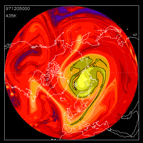
In the lower stratosphere, the potential vorticity (PV) can be considered as a conservative quantity along an air mass trajectory on an isentropic surface for 10 days periods. Ozone in the lower stratosphere is also a semi-passive tracer and is well correlated with potential vorticity. It can be used to visualise the presence of filaments. Several high resolution models of the advected PV field will be used during METRO to interpret the observations.
1) Routine observations (lidar/radar network):
2) Intensive periods of observations:
3) Airborne lidar campaigns:
Participants
CNRS - Service d'Aéronomie, France
Dr. Alain HAUCHECORNE, coordinator of METRO
alain.hauchecorne@aerov.jussieu.fr
Dr. Sophie GODIN
sophie.godin@aero.jussieu.fr
CNRS - Laboratoire de Météorologie Dynamique, France
Dr. Bernard LEGRAS
legras@lmd.ens.fr
UWA University of Wales, Physics Department , UK
Dr. Geraint VAUGHAN
gxv@aber.ac.uk
CAS, Cambridge University, Physics Department, UK
Dr. Glenn Derek CARVER
glenn@atm.ch.cam.ac.uk
NILU Norsk Institut for Luftforskning, Norway
Dr. Georg HANSEN
georg@nilu.no
IAP Institut für Atmosphärenphysik, University of Rostock, Germany
Dr. Werner SINGER
singer@iap-kborn.d400.de
GAP University of Geneve, Group of Applied Physics, Switzerland
Dr. Cristina FLESIA
cristina. flesia@physics.unige.ch
Back to home page of THESEO